library(dplyr)
library(purrr)
library(sf)
library(ggplot2)Proxy geos update
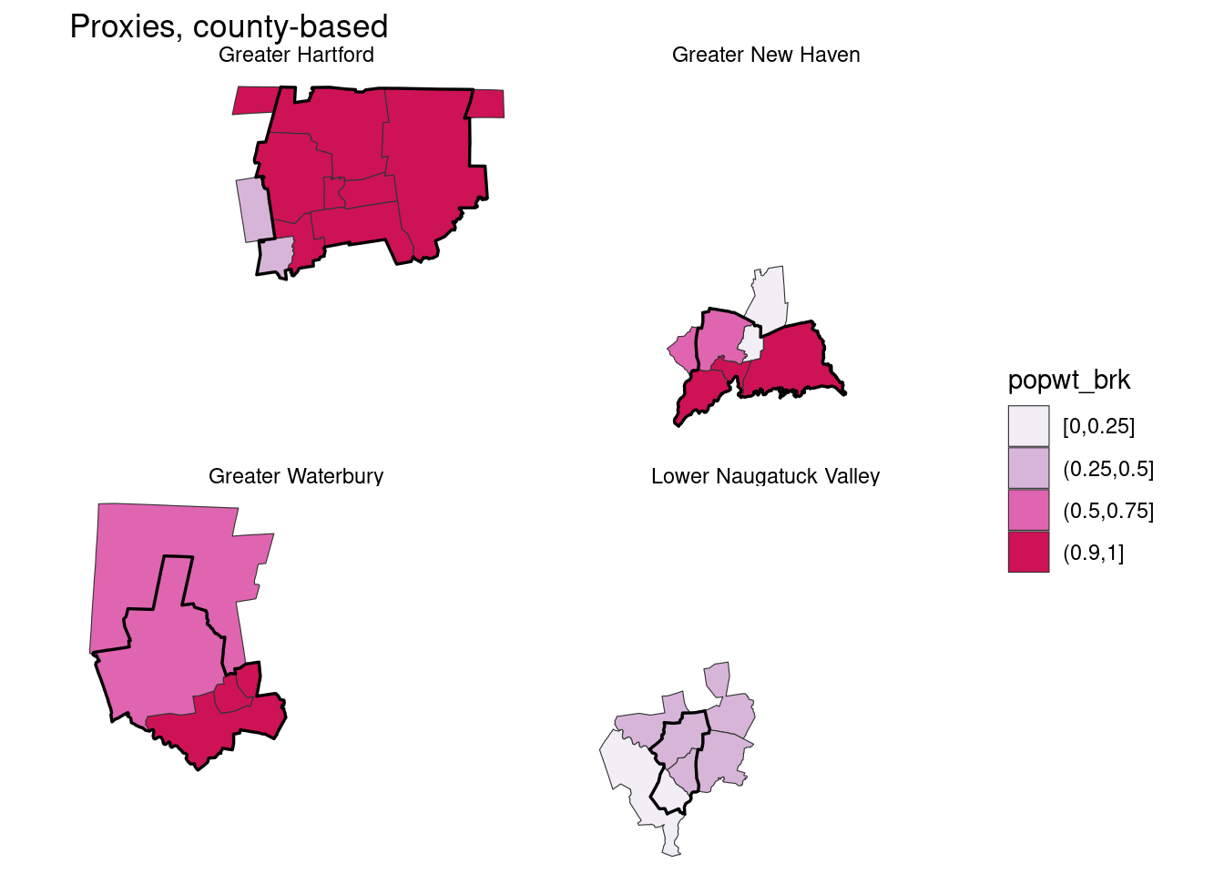
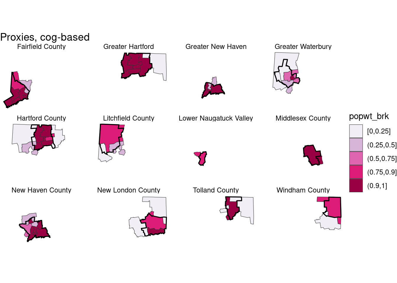
I redid the usual proxy PUMAs crosswalk in the cwi package, for both county-based PUMAs (2021 ACS) and COG-based PUMAs (2022). This is a sanity check / reference of them.
ct_sf <- st_union(cwi::town_sf)

puma_sf <- list(county = 2021, cog = 2022) |>
  map(\(x) tigris::pumas(state = "09", year = x)) |>
  map(select, puma = matches("GEOID")) |>
  map(st_intersection, ct_sf) # cut to shorelines

reg_df <- tibble::enframe(cwi::regions, name = "region", value = "town") |>
  tidyr::unnest(town) |>
  filter(region %in% cwi::proxy_pumas$county$region | region %in% cwi::proxy_pumas$cog$region)

reg_sf <- reg_df |>
  inner_join(cwi::town_sf, by = c("town" = "name")) |>
  st_as_sf() |>
  group_by(region) |>
summarise()imap(puma_sf, function(sf, id) {
proxy <- cwi::proxy_pumas[[id]]
inner_join(sf, proxy, by = "puma") |>
mutate(popwt_brk = cut(pop_weight, breaks = c(0, 0.25, 0.5, 0.75, 0.9, 1), include.lowest = TRUE)) |>
ggplot() +
geom_sf(aes(fill = popwt_brk), color = "gray20", linewidth = 0.2) +
geom_sf(data = reg_sf |> filter(region %in% proxy$region), fill = NA, color = "black", linewidth = 0.6) +
scale_fill_brewer(palette = "PuRd") +
facet_wrap(vars(region)) +
theme_void() +
labs(title = stringr::str_glue("Proxies, {id}-based"))
})$county
$cog
Extra towns added to each region’s proxies, i.e. these are towns in a puma that’s used in the proxy but not in the original region, with that puma’s population-based weight.
town_puma <- distinct(cwi::xwalk, town, puma_fips_cog)
inner_join(town_puma, cwi::proxy_pumas$cog, by = c("puma_fips_cog" = "puma")) |>
  left_join(reg_df |> mutate(in_reg = TRUE), by = c("region", "town")) |>
  tidyr::replace_na(list(in_reg = FALSE)) |>
  group_by(region, in_reg, pop_weight) |>
  summarise(towns = toString(sort(town))) |>
  filter(!in_reg) |>
knitr::kable()| region | in_reg | pop_weight | towns |
|---|---|---|---|
| Fairfield County | FALSE | 0.2579971 | Ansonia, Beacon Falls, Derby, Naugatuck, Oxford, Seymour, Southbury |
| Fairfield County | FALSE | 0.8495731 | Bridgewater, New Milford |
| Greater Hartford | FALSE | 0.1073474 | Ashford, Brooklyn, Canterbury, Chaplin, Eastford, Hampton, Killingly, Plainfield, Pomfret, Putnam, Scotland, Sterling, Thompson, Union, Voluntown, Woodstock |
| Greater New Haven | FALSE | 0.3681606 | Meriden, Wallingford |
| Greater Waterbury | FALSE | 0.1504269 | Bethel, Brookfield, Danbury, New Fairfield, Newtown, Sherman |
| Greater Waterbury | FALSE | 0.1835735 | Barkhamsted, Burlington, Canaan, Colebrook, Cornwall, Hartland, Harwinton, Kent, New Hartford, Norfolk, North Canaan, Salisbury, Sharon, Torrington, Winchester |
| Greater Waterbury | FALSE | 0.4411045 | Ansonia, Derby, Seymour, Shelton |
| Greater Waterbury | FALSE | 0.5903079 | Bristol, Plymouth |
| Hartford County | FALSE | 0.0528725 | Andover, Bolton, Columbia, Coventry, Ellington, Hebron, Mansfield, Somers, Tolland, Willington |
| Hartford County | FALSE | 0.1008288 | Barkhamsted, Canaan, Colebrook, Cornwall, Goshen, Harwinton, Kent, Litchfield, Morris, New Hartford, Norfolk, North Canaan, Roxbury, Salisbury, Sharon, Torrington, Warren, Washington, Winchester |
| Hartford County | FALSE | 0.3435833 | Bethlehem, Cheshire, Middlebury, Plymouth, Prospect, Thomaston, Watertown, Wolcott, Woodbury |
| Hartford County | FALSE | 0.7847891 | Vernon |
| Litchfield County | FALSE | 0.1504269 | Bethel, Brookfield, Danbury, New Fairfield, Newtown, Sherman |
| Litchfield County | FALSE | 0.3069919 | Bristol, Cheshire, Middlebury, Prospect, Wolcott |
| Litchfield County | FALSE | 0.8991712 | Burlington, Hartland |
| Lower Naugatuck Valley | FALSE | 0.8753968 | Southbury |
| Middlesex County | FALSE | 0.9427199 | Lyme, Old Lyme |
| New Haven County | FALSE | 0.3492279 | Bethlehem, Bristol, Plymouth, Thomaston, Watertown, Woodbury |
| New Haven County | FALSE | 0.7422221 | Shelton |
| New London County | FALSE | 0.0239472 | Ashford, Brooklyn, Canterbury, Chaplin, Eastford, Hampton, Killingly, Plainfield, Pomfret, Putnam, Scotland, Stafford, Sterling, Thompson, Union, Woodstock |
| New London County | FALSE | 0.0572801 | Chester, Clinton, Cromwell, Deep River, Durham, East Haddam, East Hampton, Essex, Haddam, Killingworth, Middlefield, Middletown, Old Saybrook, Portland, Westbrook |
| New London County | FALSE | 0.8451581 | Windham |
| Tolland County | FALSE | 0.1159020 | Ashford, Brooklyn, Canterbury, Chaplin, Eastford, Hampton, Killingly, Plainfield, Pomfret, Putnam, Scotland, Sterling, Thompson, Voluntown, Woodstock |
| Tolland County | FALSE | 0.2152109 | East Hartford, Manchester |
| Tolland County | FALSE | 0.9471275 | Marlborough |
| Windham County | FALSE | 0.1548419 | Bozrah, Colchester, Franklin, Griswold, Lebanon, Ledyard, Lisbon, Montville, North Stonington, Norwich, Preston, Salem, Sprague |
| Windham County | FALSE | 0.8601508 | Stafford, Union, Voluntown |
Cool that some of these fit better. Greater Hartford is almost exactly right—they had to steal Stafford for the Windham County-area PUMA to make it to 100k. The Valley is very close, and Southbury is similar enough to the other towns in the Valley. Greater Watebury is still weird.
Once there’s 2022 PUMS data, would be good to add a sanity check here to make sure numbers match closely enough btw ACS tables and PUMS-based estimates.